Monuments I Have Known |
All monuments found in the field are considered evidence of a boundary location and not proof of that location. That being said, there are many different things that can qualify as being evidence of boundary line and property corners. Part of the professional judgement used by land surveyors is deciding when evidence is a monument and when it is just some debris. Here are some of the more common and interesting monuments I have found over the years.
Pipe – Pipes of many sizes are very common. I have seen them range from ¼ inch to 6 inches in diameter, I.D. (inside diameter), with ½ inch being the most common. In some parts of the country, the O.D. (outside diameter) is now being used to identify the pipe sizes because of the difficulty to determine sizes after the top of the pipe has been mushroomed while being pounded into the ground.
Rebar – I have seen rebar ranging from ¼ inch to 1-1/2 inch with ½” being most common. Newer ones are supposed to be capped or tagged but the caps are often knocked off or deteriorated to the point where they are hard to read.
Caps and Tags – Caps are most often plastic, but may also be aluminum or brass. I have seen brass tags wired to the monument in some areas of the country. The caps and tags are supposed to have the license number of the surveyor or survey company, or in some cases another unique identifier is allowed. Plastic caps often deteriorate quickly under direct sunlight, becoming illegible in less than 10 years, while buried plastic caps may last from ten years to indefinitely, depending on the circumstances. Aluminum caps allow more information to be stamped on them, but are sometimes knocked off of the rebar or pipe and may suffer from deterioration from the electrolysis of the dissimilar metals.
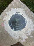
Concrete – Concrete can be an excellent monument when constructed properly, but tends to be very expensive to build or install. Newer concrete monuments are often poured in place with an aluminum cap set flush with the concrete. MoDOT used concrete posts as right-of-way markers for decades.
Stones – While the first monuments in Missouri that were set by the General Land Office from 1809 on were wood stakes, these quickly deteriorated and were commonly replaced with stones. These stones are excellent durable monuments but can sometimes be hard to find because they are not magnetized for our magnetic locators to find and vegetation can grow up around them. On rocky ground, cairns (piles of stones) were often built where an adequate hole could not be dug to place a stone.
Drill holes in concrete or stone – In urban areas or on rock ledge it can be difficult or impossible to set a pipe or rebar. Often, a hole is drilled in the concrete or stone to mark the corner. The better way to do this in concrete is to drill the hole and to set a recessed brass washer with a concrete nail. This is uncommon in central Missouri.
Chiseled or Cut Crosses ( X) in Concrete - In urban areas it can be difficult or impossible to set a pipe or rebar. Often, a chiseled or cut cross (X) is cut in the concrete to mark the corner.
Nails (Common, 60d, PK & MAG) – In some places, such as tree roots, fence posts and sometimes asphalt or concrete, nothing else seems to work, so a nail may be set. Sometimes these are marked with metal tags such as steel or brass washers or bottle caps. Beware that often reference markers are set this way, helping to find the original corner, without actually being the original corner.
Fences – Although fences are typically evidence of a boundary location and not proof of the boundary location, when there is no better evidence, fence lines can become boundary lines and fence corners can become boundary corners.
Signs - Some signs, such as those yellow triangular MoDOT signs, are evidence of property boundary locations. The were often set near the corner, but were not intended to be the actual corner. I have found them right where they are supposed to be and I have often found them off by a few feet.
Buildings - Although buildings are typically evidence of a boundary location and not proof of the boundary location, when there is no better evidence, buildings can become boundary lines and building corners can become boundary corners. This is especially true in urban areas where the building may have been constructed with no setback from the property line.
Roads – In some situations there is nothing out there to find, or the boundary is defined as a roadway, wherever that may be. In these cases, the roadway may be the boundary line.
Sidewalks – Sometimes sidewalks were poured based on boundary evidence that was later destroyed, such as a telephone company putting in new cable, ripping out the monuments and not replacing them. In these cases, the sidewalk may be used to determine the correct location of the corners and lines. Keep in mind that the back edge of sidewalks are not normally set right on the property line.
Trails – I have had boundary lines described as being the Boone Salt Trail and as various hiking trails, or the original wagon road through the wilderness. Some of these are only identifiable from old maps and a very careful look at the terrain.
Axles – In some places buggy axles, Model A axles or other automobile axles have been set.
Gun Barrels – In some places old gun barrels have been set. Some of the ones I found were even the old style octagonal barrels or muskets with no rifling.
Blazed Trees – Some of the oldest and most persistent markings are trees blazed with an axe or adze.
Tree Stumps – If the tree was the corner and it was cut down, you may be able to find its stump. If the tree was the corner and it died a long time ago, you may be able to find the hole where its stump rotted out from.
Party (Common) Walls – In urban areas, where buildings are set flush against each other, a central, common, wall between the buildings may be the monument.
Pipe – Pipes of many sizes are very common. I have seen them range from ¼ inch to 6 inches in diameter, I.D. (inside diameter), with ½ inch being the most common. In some parts of the country, the O.D. (outside diameter) is now being used to identify the pipe sizes because of the difficulty to determine sizes after the top of the pipe has been mushroomed while being pounded into the ground.
Rebar – I have seen rebar ranging from ¼ inch to 1-1/2 inch with ½” being most common. Newer ones are supposed to be capped or tagged but the caps are often knocked off or deteriorated to the point where they are hard to read.
Caps and Tags – Caps are most often plastic, but may also be aluminum or brass. I have seen brass tags wired to the monument in some areas of the country. The caps and tags are supposed to have the license number of the surveyor or survey company, or in some cases another unique identifier is allowed. Plastic caps often deteriorate quickly under direct sunlight, becoming illegible in less than 10 years, while buried plastic caps may last from ten years to indefinitely, depending on the circumstances. Aluminum caps allow more information to be stamped on them, but are sometimes knocked off of the rebar or pipe and may suffer from deterioration from the electrolysis of the dissimilar metals.
Concrete – Concrete can be an excellent monument when constructed properly, but tends to be very expensive to build or install. Newer concrete monuments are often poured in place with an aluminum cap set flush with the concrete. MoDOT used concrete posts as right-of-way markers for decades.
Stones – While the first monuments in Missouri that were set by the General Land Office from 1809 on were wood stakes, these quickly deteriorated and were commonly replaced with stones. These stones are excellent durable monuments but can sometimes be hard to find because they are not magnetized for our magnetic locators to find and vegetation can grow up around them. On rocky ground, cairns (piles of stones) were often built where an adequate hole could not be dug to place a stone.
Drill holes in concrete or stone – In urban areas or on rock ledge it can be difficult or impossible to set a pipe or rebar. Often, a hole is drilled in the concrete or stone to mark the corner. The better way to do this in concrete is to drill the hole and to set a recessed brass washer with a concrete nail. This is uncommon in central Missouri.
Chiseled or Cut Crosses ( X) in Concrete - In urban areas it can be difficult or impossible to set a pipe or rebar. Often, a chiseled or cut cross (X) is cut in the concrete to mark the corner.
Nails (Common, 60d, PK & MAG) – In some places, such as tree roots, fence posts and sometimes asphalt or concrete, nothing else seems to work, so a nail may be set. Sometimes these are marked with metal tags such as steel or brass washers or bottle caps. Beware that often reference markers are set this way, helping to find the original corner, without actually being the original corner.
Fences – Although fences are typically evidence of a boundary location and not proof of the boundary location, when there is no better evidence, fence lines can become boundary lines and fence corners can become boundary corners.
Signs - Some signs, such as those yellow triangular MoDOT signs, are evidence of property boundary locations. The were often set near the corner, but were not intended to be the actual corner. I have found them right where they are supposed to be and I have often found them off by a few feet.
Buildings - Although buildings are typically evidence of a boundary location and not proof of the boundary location, when there is no better evidence, buildings can become boundary lines and building corners can become boundary corners. This is especially true in urban areas where the building may have been constructed with no setback from the property line.
Roads – In some situations there is nothing out there to find, or the boundary is defined as a roadway, wherever that may be. In these cases, the roadway may be the boundary line.
Sidewalks – Sometimes sidewalks were poured based on boundary evidence that was later destroyed, such as a telephone company putting in new cable, ripping out the monuments and not replacing them. In these cases, the sidewalk may be used to determine the correct location of the corners and lines. Keep in mind that the back edge of sidewalks are not normally set right on the property line.
Trails – I have had boundary lines described as being the Boone Salt Trail and as various hiking trails, or the original wagon road through the wilderness. Some of these are only identifiable from old maps and a very careful look at the terrain.
Axles – In some places buggy axles, Model A axles or other automobile axles have been set.
Gun Barrels – In some places old gun barrels have been set. Some of the ones I found were even the old style octagonal barrels or muskets with no rifling.
Blazed Trees – Some of the oldest and most persistent markings are trees blazed with an axe or adze.
Tree Stumps – If the tree was the corner and it was cut down, you may be able to find its stump. If the tree was the corner and it died a long time ago, you may be able to find the hole where its stump rotted out from.
Party (Common) Walls – In urban areas, where buildings are set flush against each other, a central, common, wall between the buildings may be the monument.